
Welcome to the Raids Over York Interactive Digital Map page.
The Raids Over York digital team, led by the University of York’s Department of Archaeology, is delighted to launch an interactive digital map in time for the 80th anniversary of the Baedeker Raid on April 29 2022.
The map records how and where people experienced the raids at the time. It includes structures that were built to allow them to best cope with the raids, and also where there’s evidence of the war still remaining today. Hopefully it helps raise appreciation of these structures and the stories behind them.
The map allows you to explore widely across the city so as to better understand how our communities were affected by the 11 raids on the city.
Using the Map
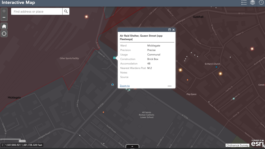
- Use your mouse to zoom in and pan out around the map.
- Click the markers to see more information
- You can see a legend explaining the symbols, switch the layers on and off and filter the results using the icons in the the top right of the map.
- Use the time slider to see the events by raid.
Interactive
Being interactive, you can contribute to the project to add your own data: a public air-raid shelter or bomb crater you know of, a photo of a member of your family in their ARP Warden or other civilian defence uniform, perhaps?
Just get in contact with the Raids Over York Team via raidsoveryork@outlook.com, using our social media channels, or write to us at: ‘Raids Over York’, Fairfax House, Castlegate, York. YO1 9RN.
Here’s some teasers of what the digital map offers …


Spotted a mistake?
There’s thousands of individual items of data on the map with thousands more to come. Our team of volunteers have worked tirelessly in cross-referencing data. Inevitably, however, there will be a few mistakes made when plotting the data, especially in attributing locations, with some areas largely rebuilt after the war. If you spot a mistake, please do let us know via raidsoveryork@outlook.com
Where’s my community’s information?
If you live in an outlying area of the city, you might notice there’s distinctly less information for your area on the map. This is due to the changes in the York boundary since the war. Simply put, York’s boundary during the war was much smaller than the current City of York boundary.
Sadly the information made or kept by local authorities immediately beyond York was never as detailed or, if it was, it is yet to be found. We hope to work with local history groups in these areas to compile data on public air-raid shelters, addresses of air-raid wardens and other details. If and when we find this information, we will be glad to add it to the map.
With thanks
The digital map is due to the hard work of the University of York’s Department of Archaeology and its use of its digital heritage expertise.
The map has been created and overseen by Dr Helen Goodchild. The data has been digitised by Helen and Ioanna Efstathoulidou, and with further assistance on the map and accompanying digital material from several University of York undergraduate and postgraduate students. These include:
- Alexandra Rive
- Alfie Talks
- Andrew Hill
- April Mitchell
- Ariane Da Silva Palmas
- Aubrey Steingraber
- Benedict Dyson
- Bryony Moss
- Cath Foster
- Daniel Hames
- Diana Mogrovejo-Prado
- Eliza Joy Hibionada
- Filsan Arale
- Freya Greaves
- Hannah Seymour
- Isabel Adams
- Isabelle Diggle
- Jee Kim
- Leon Corneille Cowell
- Mina Jachimowicz
- Prachi Pol
- Richard Anderson
The ‘Photo Tour’ was compiled by Hannah Seymour using images from the York Explore photographic collection and other sources.
The map data has come from archive sources, including York Explore Libraries & Archive and a cornucopia of material collected over the years by Wing-Commander Newbould.
The headshots of Air-Raid Precaution Wardens are taken from photos held at York Explore Libraries & Archives, with additional assistance in identifying some of the wardens from David Poole and members of York Past & Present Facebook group.
The home addresses of all of York’s air-raid wardens – over 2,000 of them, with many still being added – comes from the research of Anna Cook of YAYAS and Holgate Local History Group.
We are grateful to you all for your time, effort, and knowledge in producing the digital map ~ The Raids Over York Team.

There is a substantial below ground concrete shelter between our house (76 Scarcroft Road) and our neighbours at 78. Happy to provide a ccess.
LikeLiked by 1 person
Hi Martin. Sounds amazing – we’d love to come and see it!! Do you think it was a public or private shelter?
LikeLiked by 1 person
How very interesting, I must return to this later. I was born in the Purey Cust Nursing Home on 24th June 1942, and I see from the details on the map that a bomb detonated very close by on the Precentor’s Court during the raid on 29th April 1942. Perhaps it is a good job that I did not arrive about 8 weeks earlier!
If I may comment on the map, I know that the raid happened at night, but I find the very dark colour of the map makes it difficult to see the details of streets and buildings etc. If there is a means of lightening it, then I have not found it.
LikeLiked by 1 person
Hi Jeremy, Yes, lucky to arrive a few weeks late for the Raid! We’ll pass your feedback on the dark-colour tone of the street layer map on to the Digital Team behind the map. Thanks.
LikeLiked by 1 person